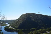
🌄 Delaware Water Gap National Recreation Area is a stunning 70,000-acre expanse straddling Pennsylvania and New Jersey, where the Delaware River slices through the Appalachian Mountains, forming the dramatic "gap" between Mount Minsi and Mount Tammany.
🏞️ Landscape & Natural Features
- River Corridor: 40 miles of the Middle Delaware National Scenic River flow through the park, offering serene views and water activities.
- Waterfalls: Home to some of the tallest in the region, including Raymondskill Falls (PA’s tallest) and Buttermilk Falls (NJ’s tallest).
- Trails: Over 150 miles of hiking paths, including 28 miles of the Appalachian Trail, wind through forests, ridges, and riverbanks.
🐾 Recreation & Activities
- Hiking & Biking: Trails range from easy boardwalks to rugged climbs with panoramic overlooks.
- Water Sports: Canoeing, kayaking, swimming, and fishing are popular along the Delaware River.
- Camping: Includes riverside sites for paddlers and backcountry options along the Appalachian Trail.
- Winter Fun: Snowshoeing, cross-country skiing, and even ice climbing at Raymondskill Falls.
🏛️ Cultural & Historical Highlights
- Minisink Region: Rich in Native American and colonial history, with archaeological sites and preserved 19th-century villages like Millbrook.
- Tocks Island Legacy: The park was born from a controversial dam project that was canceled in 1978, leaving behind a vast natural refuge.
📍 Visitor Info
- Location: Headquarters in Bushkill, PA; spans Monroe, Pike, and Northampton counties in PA and Sussex and Warren counties in NJ.
- Access Points: Popular spots include Dingmans Falls, Smithfield Beach, and Milford Beach.
- Fees: No entrance fee, but some beaches and parking areas charge seasonal fees.
Phone
Category
Address
Delaware Water Gap National Recreation Area
P.O. Box 2
Bushkill, PA 18324
United States